
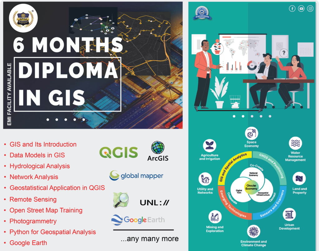
Diploma Course 🏆🎓in GIS and Remote Sensing where you will learn how to collect, analyze, and visualize geospatial data using the latest software and technologies.
🤩 Let us assure you that anyone can take up our Six Months Diploma Course
🏛️Mode : Both Online and Offline
🌟Admission are going on For the 2024- 2025 session (Book your slots)
💳 Fees : ₹ 37,500/-
🤩Fees Payable at installment (EMI facility Also available).
- GIS and Its Introduction
- Introduction to GIS
- What is GIS and the interrelationship with maps
- Types of Maps GIS deals with
- History and Development of GIS
- GIS Applications
- Map Fun Activity
- Introduction to QGIS
- Introduction to QGIS and its Interface
- Creating and Exploring a Basic Map (Tutorial)
- Working on Symbology
- Introduction to GIS
- Working with data in QGIS
- Data Capture in GIS
- Working with Attributes
- Importing Spreadsheets and CSV files
- Performing Spatial Joins
- Performing Table Joins
- Editing GIS Data (Digitizing Map data)
- Data Models in GIS
- Classifying Vector Data
- Mapping Air Quality Index
- Visualizing Census Tracks
- Mapping Census Data
- Vector Analysis- Vector Styling
- Simple Vector Analysis
- Performing Spatial Queries
- Symbolizing points of varying size
- Creating a Choropleth Map
Data model in GIS: Raster Data Model
- Raster Data Introduction
- Raster Analysis in QGIS
- Basics of Raster Styling and Analysis
- Raster Mosaicking and Clipping
- Working with Terrain Data
- Advanced Raster Analysis
QGIS Applications in Hydrology and Concept of DTM, DEM Analysis
- Introduction to Hydrology in GIS and its applications
- Calculating the Areal mean Rainfall
- LIDAR data 3d Visualization
- 3D with GIS and Aerialod
QGIS Applications in Network Analysis
- Basics of Network and Visualization and routing
- Servicing area using open route services.
- Travel Time Analysis with Uber Movement
- Locating the nearest facility using OD Matrix
- Calculating Street Intersection Density
Geostatistical Application in QGIS
- Introduction to Geo statistics in QGIS
- Calculating line Lengths and Statistics
- Calculating Raster Area
- Sampling Raster Area Using Points, Line, and Polygons
- Interpolating Point Data
- Creating Heatmaps
- Creating Time Series Maps
Theory in Remote Sensing
- Fundamentals of Remote Sensing
- Electromagnetic Waves and their Spectrum
- Atmospheric Interaction
- Reflection and absorption
- Passive Imaging Techniques
- Active Imaging Techniques
- Spatial Resolution
- Temporal Resolution
- Spectral Resolution
- Radiometric Resolution
- Download and display Satellite Imagery in QGIS
QGIS In Remote Sensing
- Calculate and use spectral Indices.
- Topography Mapping and improving water classification.
- Visual Interpretation with a tutorial
QGIS in Remote Sensing
- Unsupervised Classification
- Supervised Classification
- Pre-Processing of the data
Editing on ArcMap, ArcMap Introduction
- Introduces the editing environment, including the terminology and ArcMap user interface.
- Learn how to create features from existing features and how to edit existing features.
- Labelling and Annotations on ArcMap
- Topological Application on ArcMap
- Transformation of Data
Arc Map in Remote Sensing and Processing of Raster Imagery
- Exercise 1: Creating a mosaic dataset.
- Exercise 2: Creating multiple mosaic datasets from a single mosaic dataset.
- Exercise 3: Creating and using a mosaic dataset with an altering viewpoint.
- Exercise 4: Creating a mosaic dataset using the MATCH-AT raster type for orthorectification.
- Exercise 5: Color balancing a mosaic dataset.
- Exercise 6: Color balancing a raster catalogue.
- Exercise 7: Creating a pan-sharpened natural color mosaic dataset.
- Exercise 8: Creating a mosaic dataset to contain Landsat imagery.
ArcMap in Network Analysis and Geocoding
- Finding a route with trip planning
- Finding a route with stops reordering and network restrictions
- Creating an address locator
- Creating a composite address locator
- Finding Addresses
- Geocoding addresses in a table and rematching unmatched addresses
- Using alternate street names and place-name aliases
Working with UNL Platform and Felt Platform
- UNL Studio classes Wee
- Working on Felt Platform
Advance QGIS Topics
- Working with WMS and WFS layers in QGIS
- Handling Invalid Geometries
- Batch Process Using Processing Framework
- Automating complex workflows using a processing builder
- Automating Map Creation with Print Layout Atlas
- Multi-Criteria Overlay Analysis
Mapping and Visualization on ArcMap
Tools on Arc Map
- Working on Geoprocessing tools such as Overlay and Proximity Analysis
- Working on Model Builder
Open Street Map Training
- Open Street Map and the Humanitarian Concept
- Mapping Buildings on ID Editor
- Road Mapping
- Mapping Landcover
- Using Map Roulette
Advanced Training on OSM
- Mapping on JOSM
- Mapping on advanced ID Editor
- Mapping on Mapillary
- Mobile OSM mapping POI features using Every door, Organic Maps and Map Swipe
Photogrammetry
- Basics of Photogrammetry
- What is Ground Sampling Distance
- Capturing RGB Images
- Introduction to Flight Planning
- Generating GCP
- Generating Point Cloud data
- Generating DEM and Ortho mosaic data
- Python for Geospatial Analysis
- Essentials of Google Earth
- End- to End Google Earth Engine
Electives
- Radar Remote Sensing through SNAP
- Repository training of Sentinel Hub, Wekeo and Planet Imageries
- Hyperspectral Remote Sensing
** Above mentioned modules are subject to change at any moment of the course, depending on the trend of the current GIS market and some other external factors.